Portal:Pennsylvania
The Pennsylvania Portal Pennsylvania (/ˌpɛnsɪlˈveɪniə/ ⓘ, lit. 'Penn's forest country'), officially the Commonwealth of Pennsylvania (Pennsylvania Dutch: Pennsylvanie), is a state spanning the Mid-Atlantic, Northeastern, Appalachian, and Great Lakes regions of the United States. Pennsylvania borders Delaware to its southeast, Maryland to its south, West Virginia to its southwest, Ohio and the Ohio River to its west, Lake Erie and New York to its north, the Delaware River and New Jersey to its east, and the Canadian province of Ontario to its northwest. Pennsylvania was founded in 1681 through a royal land grant to William Penn, the son of the state's namesake. Prior to that, between 1638 and 1655, a southeast portion of the state was part of New Sweden, a Swedish Empire colony. Established as a haven for religious and political tolerance, the colonial-era Province of Pennsylvania was known for its relatively peaceful relations with native tribes, innovative government system, and religious pluralism. Pennsylvania played a vital and historic role in the American Revolution and the ultimately successful quest for independence from the British Empire, hosting the First and Second Continental Congress leading to the adoption of the Declaration of Independence. On December 12, 1787, Pennsylvania became the second state to ratify the U.S. Constitution. The bloodiest battle of the American Civil War, at Gettysburg over three days in July 1863, proved the war's turning point, leading to the Union's preservation. Throughout the late 19th and 20th centuries, the state's manufacturing-based economy contributed to the development of much of the nation's early infrastructure, including key bridges, skyscrapers, and military hardware used in U.S.-led victories in World War I, World War II, and the Cold War. Pennsylvania's geography is highly diverse. The Appalachian Mountains run through the center of the state; the Allegheny and Pocono mountains span much of Northeastern Pennsylvania; close to 60% of the state is forested. While it has only 140 miles (225 km) of waterfront along Lake Erie and the Delaware River, Pennsylvania has the most navigable rivers of any state in the nation, including the Allegheny, Delaware, Genesee, Ohio, Schuylkill, Susquehanna, and others. (Full article...) This is a Featured article, which represents some of the best content on English Wikipedia..
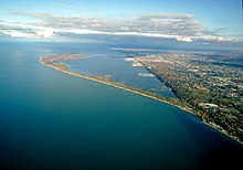
Presque Isle State Park (/prɛsk/ PRESK) is a 3,112-acre (1,259 ha) Pennsylvania State Park on an arching, sandy peninsula that juts into Lake Erie, 4 miles (6 km) west of the city of Erie, in Millcreek Township, Erie County, Pennsylvania, in the United States. The peninsula sweeps northeastward, surrounding Presque Isle Bay along the park's southern coast. It has 13 miles (21 km) of roads, 21 miles (34 km) of recreational trails, 13 beaches for swimming, and a marina. Popular activities at the park include swimming, boating, hiking, biking, and birdwatching. The recorded history of Presque Isle begins with the Erielhonan, a Native American tribe who gave their name to Lake Erie, and includes French, British, and American forts, as well as serving as a base for Commodore Oliver Hazard Perry's fleet in the War of 1812. With the growing importance of shipping on Lake Erie in the 19th century, Presque Isle became home to several lighthouses and what later became a United States Coast Guard station. In 1921, it became a state park, and as of 2007 it hosts over 4 million visitors per year, the most of any Pennsylvania state park. (Full article...)Selected geography article - State Route 1002 (SR 1002), locally known as Tilghman Street and Union Boulevard, is a major 13.8 mi (22.2 km) long east–west road in the Lehigh Valley region of eastern Pennsylvania. The majority of the roadway is the former alignment of U.S. Route 22, maintained by the Pennsylvania Department of Transportation as a Quadrant Route, and is not signed except on small white segment markers. Tilghman Street begins at Pennsylvania Route 100 in Fogelsville, though SR 1002 continues west on Main Street, also known as the old US 22, to the intersection of Church Street (SR 3014). It becomes Union Boulevard just east of the bridge over the Lehigh River in Allentown; SR 1002 ends at the interchange with Pennsylvania Route 378 in Bethlehem. Union Boulevard continues over Monocacy Creek, which forms the border between Lehigh and Northampton Counties, and ends in downtown Bethlehem. (Full article...)Selected image - Credit: Kev72 Downtown Harrisburg and the Pennsylvania State Capitol Building as seen from Cumberland County, across the Susquehanna River. Did you know -
Related portalsWikiprojectsThis is a Good article, an article that meets a core set of high editorial standards.
 Hershey Creamery Company, also known as Hershey's Ice Cream, is an American creamery that produces ice cream, sorbet, sherbet, frozen yogurt, and other frozen desserts such as smoothies and frozen slab-style ice cream mixers. It was founded by Jacob Hershey and four of his brothers in 1894 and taken over by the Holder family in the 1920s. The company was one of the first to offer consumers pre-packaged ice cream pints. The family-owned business has approximately 450 employees and operates 30 distribution centers in 28 states across the Eastern and Northeastern United States. It is a publicly traded company, with its stocks listed only on Pink Sheets as the company offers a limited number of shares to potential shareholders. In 1998, it modernized its operations to increase efficiency and reduce overhead. (Full article...)Selected article -The Pennsylvania Dutch (Pennsylvania Dutch: Pennsylvanisch Deitsche), also referred to as Pennsylvania Germans, are an ethnic group in Pennsylvania and other regions of the United States, predominantly in the Mid-Atlantic region of the nation. They largely descend from the Palatinate region of Germany, and settled in Pennsylvania during the 17th, 18th, and 19th centuries. While most were from the Palatinate region of Germany, a lesser number were from other German-speaking areas of Germany and Europe, including Baden-Württemberg, Hesse, Saxony, and Rhineland in Germany, the Netherlands, Switzerland, and the Alsace–Lorraine region of France. The Pennsylvania Dutch spoke Palatine German and other South German dialects, intermixing of Palatine, English, and other German dialects, which formed the Pennsylvania Dutch language as it is spoken today. (Full article...)Pennsylvania news
CategoriesState factsState Facts
State symbols
Pennsylvania topicsGeneral imagesThe following are images from various Pennsylvania-related articles on Wikipedia.
Associated WikimediaThe following Wikimedia Foundation sister projects provide more on this subject:
Discover Wikipedia using portals |


