Wikipedia portal for content related to Myanmar (Burma)
ကြိုဆိုပါတယ်။ / Welcome to the Myanmar Portal
Myanmar, officially the Republic of the Union of Myanmar and also known as Burma (the official name until 1989), is a country in Southeast Asia. It is the largest country by area in Mainland Southeast Asia and has a population of about 55 million. It is bordered by Bangladesh and India to its northwest, China to its northeast, Laos and Thailand to its east and southeast, and the Andaman Sea and the Bay of Bengal to its south and southwest. The country's capital city is Naypyidaw, and its largest city is Yangon (formerly Rangoon).
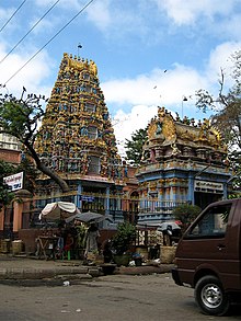
Shri Kali Temple, Burma, a Hindu temple with Dravidian architecture in YangonBurmese Indians are a group of people of Indian origin who live in Myanmar (Burma). The term 'Burmese Indian' refers to a broad range of people from South Asia, most notably from present-day countries such as India and Bangladesh. While Indians have lived in Burma for many centuries, most of the ancestors of the current Burmese Indian community emigrated to Burma from the start of British rule in the mid-19th century to the separation of British Burma from British India in 1937. During colonial times, ethnic Indians formed the backbone of the government and economy serving as soldiers, civil servants, merchants, moneylenders, mobile laborers and dock workers. A series of anti-Indian riots in the 1930s and mass emigration at the onset of the Japanese invasion of Burma in 1942 were followed in the 1960s by the forced migration of hundreds of thousands of ethnic Indians, exacerbated by internal conflict in Myanmar.
Burmese Indians today are estimated to account for approximately 5% (about 2.0–2.5 million people) of the population of Burma and are concentrated largely in the two major cities (Yangon and Mandalay) and former colonial towns (Pyin U Lwin and Kalaw). They wield considerable influence and control over the Burmese economy and have a major socio-cultural presence within the country. Amongst the well-known Burmese Indians is S N Goenka, a leading practitioner and teacher of vipassanā meditation and Helen, a well-known Bollywood film actress who is also of Anglo-Burmese descent. (Full article...)
Image 2
Portrait of the Thirty Comrades The Thirty Comrades (Burmese: ရဲဘော်သုံးကျိပ်) constituted the embryo of the modern Burmese army called the Burma Independence Army (BIA) which was formed to fight for independence from Britain. This was accomplished just before the majority of the Thirty Comrades returned with the invading Japanese Army initially through Southern Burma in December 1941.
In April 1941, small groups of Burmese youth left Burma secretly to obtain military training to fight the British colonists in the struggle for independence. Their leader was Thakin Aung San and they were sent by the Dobama Asiayone ("We Burmans Association") with the intention to get assistance from Guangzhou. By a quirk of fate, however, they ran into the Japanese instead in Amoy and arrived in Japan later to be flown to occupied parts of Sanya, in order to receive military training from the Japanese Army. They were later moved to Formosa for security reasons and subsequently returned to Burma via Vietnam and Thailand with the Japanese. On 26 December 1941, in a house (owned by a Burmese doctor) in Bangkok, about 25 of the Thirty Comrades had their blood drawn from their arms in syringes, then poured into a silver bowl from which each of them drank – thway thauk in time-honoured Burmese military tradition – pledging "eternal loyalty" among themselves and to the cause of Burmese independence. Their average age was just 24 years. A Japanese officer called Suzuki Keiji, better known among the Burmese by his nom de guerre Bo Mogyo (Commander Thunderbolt) and head of a special intelligence unit called Minami Kikan (南機関) formed in order to support a national uprising in Burma, was the mentor and principal trainer of the Thirty Comrades. The British were driven out of Burma to India during World War II. (Full article...)
Image 3
Destroyed village in Rakhine State, September 2017
The Rohingya genocide is a series of ongoing persecutions and killings of the MuslimRohingya people by the military of Myanmar. The genocide has consisted of two phases to date: the first was a military crackdown that occurred from October 2016 to January 2017, and the second has been occurring since August 2017. The crisis forced over a million Rohingya to flee to other countries. Most fled to Bangladesh, resulting in the creation of the world's largest refugee camp, while others escaped to India, Thailand, Malaysia, and other parts of South and Southeast Asia, where they continue to face persecution. Many other countries consider these events ethnic cleansing.
The persecution of Rohingya Muslims in Myanmar dates back to at least the 1970s. Since then, the Rohingya people have been persecuted on a regular basis by the government and Buddhist nationalists. In late 2016, Myanmar's armed forces and police launched a major crackdown against the people in Rakhine State which is located in the country's northwestern region. The Burmese military was accused of committing ethnic cleansing and genocide by various United Nations agencies, International Criminal Court officials, human rights groups, journalists, and governments. The UN found evidence of wide-scale human rights violations, including extrajudicial killings; summary executions; gang rapes; arson of Rohingya villages, businesses, and schools; and infanticides. At least 6,700 Rohingya were killed in the first month of attacks, between 25 August and September 24, 2017. The Burmese government dismissed these findings by stating they are "exaggerations". Using statistical extrapolations which were based on surveys which were conducted with a total of 3,321 Rohingya refugee households in Cox's Bazar, Bangladesh, a study which was conducted in January 2018 estimated that the military and the local Rakhine population killed at least 25,000 Rohingya people and perpetrated gang rapes and other forms of sexual violence against 18,000 Rohingya women and girls. They estimated that 116,000 Rohingya were beaten, and 36,000 were thrown into fires. (Full article...)
The economy of Myanmar is the seventh largest in Southeast Asia. After the return of civilian rule in 2011, the new government launched large-scale reforms, focused initially on the political system to restore peace and achieve national unity and moving quickly to an economic and social reform program. Current economic statistics were a huge decline from the economic statistics of Myanmar in the fiscal year of 2020, in which Myanmar’s nominal GDP was $81.26 billion and its purchasing power adjusted GDP was $279.14 billion. Myanmar has faced an economic crisis since the 2021 coup d'état. (Full article...)
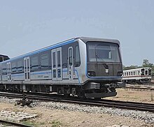
Yangon Circular Railway (Burmese: ရန်ကုန် မြို့ပတ် ရထား[jàɰ̃ɡòʊɰ̃mjo̰baʔjətʰá]) is the local commuter rail network that serves the Yangon metropolitan area. Operated by Myanma Railways, the 45.9-kilometre (28.5 mi) 39-station loop system connects satellite towns and suburban areas to the city. Circa 2008–2010, the railway had about 200 coaches, had 20 daily runs, and sold 100,000 to 150,000 tickets daily. The railway is heavily utilized by lower-income commuters, as it is (along with buses) the cheapest method of transportation in Yangon.
The hours of service have been consistent over the years, from 3:45 am to 10:15 pm daily. In 2011, the cost of a ticket for a distance of 15 miles was two hundred kyats (~eighteen US cents), and that for over 15 miles was four hundred kyats (~37 US cents). In the new currency (introduced in 2012) long distance tickets are 200 kyat (~20 US cents). (Full article...)
Image 7
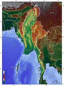
Myanmar (also known as Burma) is the northwesternmost country of mainland Southeast Asia located on the Indochinese peninsula. With an area of 261,228 sq mi (676,578 km2), it is the second largest country in Southeast Asia and the largest on mainland Southeast Asia. The kite-shaped country stretches from 10'N to 20'N for 1,275 miles (2,050 km) with a long tail running along the western coast of the Malay Peninsula.
Myanmar lies along the Indian and Eurasian Plates, to the southeast of the Tibetan Plateau. To its west is the Bay of Bengal and to its south is the Andaman Sea. The country is nestled between several mountain ranges with the Arakan Mountains on the west and the Shan Plateau dominating the east. The central valley follows the Irrawaddy River, the most economically important river to the country with 39.5 million people, including the largest city Yangon, living within its basin. The country is home to many diverse ethnic groups, with 135 officially recognized groups. It is strategically located near major Indian Ocean shipping lanes and was historically home to overland trade routes into China from the Bay of Bengal. The neighboring countries are China, India, Bangladesh, Thailand and Laos. (Full article...)
Black and white photograph of logging in Myanmar taken by a Bombay Burmah Trading Corporation official during British rule. According to a report by the Food and Agriculture Organization of the United Nations, Myanmar (also known as Burma) lost 19%, or 7,445,000 hectares (28,750 sq mi), of forest between 1990 and 2010. With forest covering as much as 70% of Burma at the time of independence, there were only slightly more than 48% forest cover left as of 2014. The deforestation rate of Myanmar has declined from 0.95% per year in the years 1990–2010 to about 0.3% per year and deforestation in Myanmar is now less than other countries of the region such as Indonesia or Vietnam, but still remains an important environmental issue. Three main factors contribute to continued deforestation: unsustainable and illegal logging, unresolved land rights and land disputes and extensive agricultural development.
Myanmar possesses the largest expanse of tropical forest in mainland Southeast Asia with a biodiversity much greater than temperate forests. As of 2010, Burma's living forest biomass holds 1,654 million metric tons of carbon and is home to over 80 endemic species. Despite the diversity and size of Burma's forests, only 6.3% of the land is protected and much of it is under the threat of deforestation. (Full article...)
Image 10
Kale Kye-Taung Nyo (Burmese: ကလေး ကျေးတောင် ညို, [kəlétɕédàʊɰ̃ɲò]; also spelled Kale Kyetaungnyo or Kalekyetaungnyo; 1385–1426) was king of Ava from 1425 to 1426, and governor of Kale Kye-Taung (Kalay) from 1406 to 1425. A top military commander during the reigns of kings Minkhaung I and Thihathu of Ava, Prince Min Nyo came to power in 1425 by overthrowing his eight-year-old nephew King Min Hla with the help of his lover Queen Shin Bo-Me. But Nyo himself was overthrown less than seven months later in 1426 by his fellow senior commander and long-time rival Gov. Thado of Mohnyin.
The eldest son of King Tarabya of Ava, Prince Nyo was the heir presumptive during his father's brief reign in 1400. He did not succeed to the throne but became a son-in-law of the successor, his half-uncle King Minkhaung I (r. 1400–1421), who in 1406 sent him to govern Kale, a remote Shan state in the northwest. The prince proved a loyal and able vassal, keeping the frontier region quiet while leading several campaigns in Ava's long running war against Hanthawaddy Pegu between 1408 and 1423. Nyo and Thado rose to be the deputy commanders-in-chief in 1412, and after the death of Crown Prince Minye Kyawswa in 1415, the duo became the leading commanders of the Ava military. (Full article...)
Image 4British soldiers remove their shoes at the entrance of Shwedagon Pagoda. To the left, a sign reads "Foot wearing is strictly prohibited" in Burmese, English, Tamil, and Urdu. (from Culture of Myanmar)
Image 8Vegetable stall on the roadside at the Madras Lancer Lines, Mandalay, January 1886. Photographer: Hooper, Willoughby Wallace (1837–1912). (from History of Myanmar)
Image 9Pagan Kingdom during Narapatisithu's reign. Burmese chronicles also claim Kengtung and Chiang Mai. Core areas shown in darker yellow. Peripheral areas in light yellow. Pagan incorporated key ports of Lower Burma into its core administration by the 13th century. (from History of Myanmar)
Image 18Protesters in Yangon carrying signs reading "Free Daw Aung San Suu Kyi" on 8 February 2021. (from History of Myanmar)
Image 19The paddle steamer Ramapoora (right) of the British India Steam Navigation Company on the Rangoon river having just arrived from Moulmein. 1895. Photographers: Watts and Skeen (from History of Myanmar)
Image 23Salween river at Mae Sam Laep on the Thai-Myanmar border (from Geography of Myanmar)
Image 24A wedding procession, with the groom and bride dressed in traditional Burmese wedding clothes, reminiscent of royal attire (from Culture of Myanmar)
Image 37A theatrical performance of the Mon dance (from Culture of Myanmar)
Image 38British soldiers dismantling cannons belonging to King Thibaw's forces, Third Anglo-Burmese War, Ava, 27 November 1885. Photographer: Hooper, Willoughby Wallace (1837–1912). (from History of Myanmar)


 Two female musicians play the saung at a performance in Mandalay. (from Culture of Myanmar)
 Former US President Barack Obama poses barefoot on the grounds of Shwedagon Pagoda, one of Myanmar's major Buddhist pilgrimage sites. (from Culture of Myanmar)
 British soldiers remove their shoes at the entrance of Shwedagon Pagoda. To the left, a sign reads "Foot wearing is strictly prohibited" in Burmese, English, Tamil, and Urdu. (from Culture of Myanmar)
 Boxing match, 19th-century watercolour (from Culture of Myanmar)
 British soldiers on patrol in the ruins of the Burmese town of Bahe during the advance on Mandalay, January 1945. (from History of Myanmar)
 Aung San Suu Kyi addresses crowds at the NLD headquarters shortly after her release. (from History of Myanmar)
 Vegetable stall on the roadside at the Madras Lancer Lines, Mandalay, January 1886. Photographer: Hooper, Willoughby Wallace (1837–1912). (from History of Myanmar)
 Pagan Kingdom during Narapatisithu's reign. Burmese chronicles also claim Kengtung and Chiang Mai. Core areas shown in darker yellow. Peripheral areas in light yellow. Pagan incorporated key ports of Lower Burma into its core administration by the 13th century. (from History of Myanmar)
 Mountains near Pindaya on the Shan Plateau (from Geography of Myanmar)
 A bull fight, 19th-century watercolour (from Culture of Myanmar)
 A large fracture on the Mingun Pahtodawgyi caused by the 1839 Ava earthquake. (from Geography of Myanmar)
 A group of Buddhist worshipers at Shwedagon Pagoda, an important religious site for Burmese Buddhists (from Culture of Myanmar)
 Recorder's Court on Sule Pagoda Road, with the Sule Pagoda at the far end, Rangoon, 1868. Photographer: J. Jackson. (from History of Myanmar)
 Protesters in Yangon with a banner that reads non-violence: national movement in Burmese, in the background is Shwedagon Pagoda. (from History of Myanmar)
 Protesters in Yangon carrying signs reading "Free Daw Aung San Suu Kyi" on 8 February 2021. (from History of Myanmar)
 The paddle steamer Ramapoora (right) of the British India Steam Navigation Company on the Rangoon river having just arrived from Moulmein. 1895. Photographers: Watts and Skeen (from History of Myanmar)
 Jade Mine in Hpakant (from Geography of Myanmar)
 Portuguese ruler and soldiers mounting an Elephant. Philips, Jan Caspar (draughtsman and engraver) (from History of Myanmar)
 Mount Popa, a dormant volcano in the Central Lowlands (from Geography of Myanmar)
 Salween river at Mae Sam Laep on the Thai-Myanmar border (from Geography of Myanmar)
 A wedding procession, with the groom and bride dressed in traditional Burmese wedding clothes, reminiscent of royal attire (from Culture of Myanmar)
 Aerial view of a burned Rohingya village in Rakhine state, Myanmar, September 2017 (from History of Myanmar)
 Saint Mary's Cathedral in Downtown Yangon is the largest Roman Catholic cathedral in Burma. (from Culture of Myanmar)
 Myinhkin thabin - equestrian sport (from Culture of Myanmar)
 Temples at Mrauk U, was the capital of the Mrauk U Kingdom, which ruled over what is now Rakhine State. (from History of Myanmar)
 Hlei pyaingbwè - a Burmese regatta (from Culture of Myanmar)
 The restored Taungoo or Nyaungyan dynasty c. 1650 CE. (from History of Myanmar)
 Myanmar (Burma) map of Köppen climate classification (from Geography of Myanmar)
 19th-century funeral cart and spire, which would form part of the procession from the home to the place of cremation (from Culture of Myanmar)
 Political Map of Burma (Myanmar) c. 1450 CE. (from History of Myanmar)
 The shores of Irrawaddy River at Nyaung-U, Bagan (from Geography of Myanmar)
 Grandfather Island, Dawei (from Geography of Myanmar)
 A theatrical performance of the Mon dance (from Culture of Myanmar)
 British soldiers dismantling cannons belonging to King Thibaw's forces, Third Anglo-Burmese War, Ava, 27 November 1885. Photographer: Hooper, Willoughby Wallace (1837–1912). (from History of Myanmar)
 A wide range of Burmese lacquerware from Bagan (from Culture of Myanmar)
 Sculpture of Myanmar mythical lion (from Culture of Myanmar)


_headquarter.jpg)


 Commons
 Wikibooks
 Wikidata
 Wikinews
 Wikiquote
 Wikisource
 Wikiversity
 Wikivoyage
 Wiktionary


